The Korean text of this paper can be translated into multiple languages on the website of http://jksee.or.kr through Google Translator.
Bimenyimana, Bugenimana, Habineza, Bushesha, and Ali:
Abstract
Objectives
This research examined the effect of urbanization on environmental justice in Rwanda from 1999 to 2019. Specifically, the research sought to document changes in land use and land cover in the study region in order to analyze the environmental consequences of urban growth in Rwanda.
Methods
Land use/land cover patterns were identified and modelled using remotely sensed data.
Results and Discussion
The findings revealed that in the majority of cases, economic development influenced land use change in various aspects, both in terms of area and intensity, which replaced agricultural land with human settlements. For example Nyagatare city, built-up areas have expanded by 15 to 20%, while forests, vegetation, and waterbodies have decreased by 49%. It has been noted that urbanization is out of step with the natural urban environment, resulting in soil erosion, violent winds, flooding, and landslides, all of which are linked to environmental injustice. Also, settlement destruction, flooding, infrastructure damage, loss of natural habitat, and agricultural loss were all linked to urban expansion, particularly uncontrolled settlements in metropolitan contexts, with 64 people killed and 178 injured in just five years.
Conclusion
Therefore, this shows that there are consequences of biodiversity losses which affect land use and land cover. To overcome, the research suggests current households located in high-risk zones be moved to the convenient zones and the government policy to focus on family planning, encouraging the flexibility of land use, crop production, and farming systems based on agroecosystem models, and strengthening the greening city strategy by raising public understanding on environmental issues.
Key words: Remote sensed data, Land use/land cover change; Urbanization impact, Environmental justice; Rwanda, Migration
1. Introduction
The increase of the world’s population is concentrated in urban settlements and has led to both opportunities and challenges [ 1]. The growth of the world’s cities, from the North to the South, and from the East to the West, is ingrained in a culture of short-term economic benefit and often unbridled consumption and production practices that compromise the sustainability of the environment. The United Nations Development Program (UNDP) defined the Agenda for Sustainable Development in 2015 as a set of 17 strategic goals covering a variety of core dimensions related to sustainable development. Cities accounted for more than 80% of global GDP, and urbanization may contribute in the long run if well managed, allowing for innovation and new development ideas [ 2]. At present, more than half of the world’s population lives in urban areas [ 3], and this rate is expected to decrease in coming years. The expansion of cities and the development of new cities is associated with an increasing demand for resources to meet the needs of potential new citizens [ 4]. This pushes many countries to create second and even third cities to support the principal city, and sometimes the cities are developed without consideration of the environmental issues (green infrastructure, housing, roads, and other networks). Urban environments in the world are increasingly facing the triple effects of pollution, and environmental degradation [ 5]. According to the IMF, Rwanda's economy is primarily rural and agriculturally based where by energy, agriculture, trade and hospitality, financial services particularly construction and tourism, accounted for more than 8% of total growth in 2018 [ 6]. Therefore, as the City of Kigali attracts most of the growth and investment, the Government of Rwanda decided, through the provisions of EDPRS2, to adopt a proactive national urban growth strategy and support the development of a network of secondary cities, while Kigali city will be developed as a regional hub [ 7]. The six secondary cities selected by the government of Rwanda are Huye, Muhanga, Musanze, Nyagatare, Rubavu, and Rusizi.
These six cities have been selected based on economic, sociological, and political criteria. During the secondary city selection, the growing population sizes, limited public financial resources, inadequate urban infrastructure, complementary facilities, and inadequate decentralization of human settlement management, mechanisms to recover the costs invested in human settlement operations have been taken into consideration. It is also significant to consider the environmental impacts, resource consumption, and pollution that may lead to environmental injustice.
Moreover, bearing in mind that these cities are often at the beginning of their urbanization process, quick wins and tangible gains are possible in terms of green growth, especially as it is a direct contribution to more dispersed growth. Accordingly, this study focuses on studying the problem in the context of a developing country with a case study of growing cities within Rwanda to study the impacts of urbanization on environmental justice.
This research study was carried out with the goal of assessing the influence of urbanization on environmental justice in Rwanda's growing cities from 1999 to 2019 based on land use and land cover changes.
2. Materials and Methods
2.1. Description of study area
The land surface of Rwanda is 26,388 km 2 and the country has a population of about 11.78 million [ 8]. Rwanda is a landlocked country in East Africa whose green, mountainous landscape has earned its nickname, “Land of a Thousand Hills”. Rwanda is in the African Great Lakes region and is highly elevated; its geography is dominated by mountains in the west and savannah to the east, with numerous lakes throughout the country.
The study was conducted in five growing cities in Rwanda; Kigali, Musanze, Nyagatare, Huye, and Rusizi Cities as described by the map below.
The study used primary and secondary data in the spatial analysis of urbanization, land use and land cover changes, and the associated impacts on environmental justice to solve the research problem and meet the study's objectives.
2.2. Landsat images enhancement
The process of creating land use/land cover maps was continued using a pixel-based approach via supervised classification, and training samples were used to create land use/land cover classifications by visualizing the false color composite results of band combinations using ArcGIS software. The table (Annex 1) describes the Landsat band combination method used to generate land use/land cover categorization maps for study areas.
To get a multispectral picture of one of the studied metropolitan areas, the individual bands from the same time period were combined appropriately. For Landsat 5 TM, Landsat 7 ETM+, and Landsat 8 OLI/TIRS, the layer combination procedure and for layer stacking. Prior to the subset process, the spatial resolution of Landsat images from 1999, 2009, and 2019 was 30m; after the subset process, it involved the pan-sharpening process to increase the resolution of images, particularly for Landsat images from 1999 and 2019 of urban areas based on the sensors used by the USGS increased spatial resolution from 30 m to 15 m.
2.3. Establishment of LULC classification maps
Due to the interpretation of Landsat imagery, land use/land cover classes were generated using the maximum likelihood classification tool in ArcGIS software to create easily recognizable classes. As a result, four significant classes were identified based on shared physical characteristics and spectral values: a) urban areas; b) forests; c) vegetation; and d) waterbodies.
2.4. Changes in LULC in selected urban areas
Change analysis was conducted using a post-grouping assessment approach that used overlay methods on categorized pictures to determine the changes that occurred in each cover type during the time period under consideration. It is the examination of self-generated classifications of different dates using a fundamental numerical mix pixel by pixel [ 9]. A s a consequence, a matrix of change classes was created to illustrate the transition from one class to the next in a cross-arrangement. Erdas Imagine 2014 was used to finish the study of theme shift. The formula below was used to calculate the percent change in land use/ land cover. Land use/land cover changes were identified using multispectral Landsat data from 1999, 2009, and 2019. It included different techniques, such as supervised classification using Landsat images using ERDAS Imagine and ArcGIS software. The findings were confirmed and validated using the built-up areas classification system, which encompasses urban areas, vegetation, woodlands, and bodies of water. The observed changes revealed a decline in some classes and an increase in others as a result of urbanization and other human-caused interactions, which are classified as major actions such as infrastructure development, the construction of new houses, roads, and other compounds that replaced forests and natural vegetation. In the majority of instances, built-up areas increased in the five metropolitan regions studied, while forest and vegetation areas decreased.
2.5. Accuracy assessment
The accuracy of the categorized picture was achieved via the use of randomly chosen and distributed ground truth points across the research region. Correctness evaluation includes ensuring the accuracy of the user, the general accuracy, and the accuracy of the producer. The total number of correctly categorized pixels in a category divided by the entire number of pixels classified in that category (row total) is a measure of commission error. The accuracy or dependability of the user is the likelihood that a pixel categorized on the map corresponds to that category on the ground. This statistic shows the likelihood of a reference pixel being identified properly and serves as a proxy for omission error. The accuracy of the producer indicates how effectively a certain region may be categorized. The overall accuracy of a category is calculated as the number of accurate pixels divided by the total number of pixels in that category obtained from the reference data (column total).
Overall accuracy = (number of pixels identified correctly)/ (total number of pixel). Chapter four summarized the accuracy assessment's findings.
The following maps indicate the distribution of the truth ground data within the 5 urban areas
3. Results and Discussion
3.1. Land use /land cover distribution in growing cities of Rwanda by 1999
3.1.1. (i). Kigali city
As shown by the below results, before the year 2000, especially in 1999, the land use/land cover distributions in Kigali City were characterized by the vegetation cover of 72.49% of the total area of Kigali City. The built-up areas occupied 21.84%, the forests covered 5.35%, while the water bodies were counted on 0.31% of the total area of the city. As shown by figure 3.1, the vegetation and built-up areas occupied the biggest portions of land, which is a normal trend in urban areas.
3.1.2. (ii). Nyagatare urban area
In 1999, the land use/land cover distributions in Nyagatare urban area were categorized by the vegetation cover of 44.15% of the total area of the Nyagatare City (annex 2).
The built-up areas occupied 36.47% and the forests covered 19.38% of the total area.
The vegetation and built-up areas were counting the biggest portions of land, which is a normal trend in the urban areas of the Eastern Province.
3.1.3. (iii). Huye urban area 1999
The urban area of Huye city in 1999 was characterized by the forest occupied at 16.48% and the vegetation were evaluated at 53.75%. The urban built up areas covered 29.77% of the total area of the Huye urban area. Like in most urban areas, the built-up areas and the vegetation occupied the biggest portions of land, which is a normal trend.
3.1.4. (iv). Rusizi urban area by 1999
By the year 1999, the land use/land cover patterns in Rusizi urban area were characterized by the vegetation cover of 54.46% of the total area of Rusizi urban area, the built-up areas occupied 35.31% and forests covered 10.22% of the total area of Rusizi urban area. The vegetation and built-up areas accounted for the biggest portions of land, which is a normal trend in urban areas in the local context.
3.1.5. (v). Musanze urban area by 1999
The results of image classification in 1999 for Musanze urban area provided the land use/land cover patterns where vegetation covered the largest portion of land at about 60.54% of the total area of Musanze urban area. The built-up areas occupied 13.47% and forests covered 25.99% of the total area in the Musanze urban area. It was observed that by 1999, Musanze city was not highly populated as the forests and vegetation areas occupied the biggest portions of land, at around 86% of the whole urban area at that time.
3.2. Land use /land cover distribution in growing cities of Rwanda in 2019
3.2.1. (i). Kigali City by 2019
The classified images of 2019 revealed the land use/land cover patterns in Kigali City, which were the built up, vegetation, forest, and water bodies. The built-up areas covered 47.68% of the total compared to the total area of Kigali City. The vegetated areas counted for 41.02% of the Kigali urban area; the forests covered 11.04%, while the water bodies were calculated for 0.26% of the total area of the city. Still, the same trend is that the vegetation and built-up areas occupied the biggest portions of land, just around 89% of the whole land.
3.2.2. (ii). Nyagatare urban area by 2019
Land use and land cover distributions in Nyagatare urban area were classified as built up, forest, and vegetation in 2019. The forests occupied an area of 1.99%, the vegetation class occupied 46.32%, and the built-up urban areas covered 51.70% of the total area of Nyagatare City urban areas.
3.2.3. (iii). Huye urban area by 2019
The urban area of Huye City in 2019 was characterized by the following land use/land cover patterns: The forests occupied 6.74% and the vegetation was estimated at 49.37%.
The urban built up areas covered 43.89% of the total area of the Huye urban area. Like in most urban areas, the built-up areas and the vegetation occupied the biggest portions of land, which is a normal trend.
3.2.4. (iv). Rusizi urban area by 2019
By the year 2019, the land use/land cover patterns in Rusizi urban area were characterized by the vegetation covering 32.36% of the total area of Rusizi urban area, the built-up areas occupied 49.71% and forests covered 17.93% of the total area of Rusizi urban area.
The vegetation and built-up areas accounted for the biggest portions of land, which is a normal trend in urban areas in the local context.
3.2.5. (v). Musanze urban area by 2019
The results of image classification in 2019 for Musanze urban area provided the land use/land cover patterns where the forests accounted for a large portion of the land at about 36.66% of the total area of Musanze urban area. The built-up areas occupied 29.58% and the vegetation covered 33.76% of the total area in the Musanze urban area. It was observed that by 2019, Musanze city was somehow balanced in terms of land use/land cover patterns.
3.2. DISCUSSION
In the growing cities of Rwanda two decades ago, the infrastructure such as buildings (roofed structures), paved surfaces (roads, parking lots), commercial and industrial sites (ports, landfills, quarries, runways) were developed and increased by 21.602%. This is due to urban expansion where people migrate from different parts of the country.
People have been concentrated in these growing cities due to their infrastructure development, such as schools, roads, hospitals, markets, and job opportunities. For Kigali city, Nyagatare and Huye urban areas, the areas occupied by infrastructure have been intensively increased by 26.74%, 22.69%, and 24.78% respectively for two decades. The influence of infrastructure on LUCC is a typical example [ 4]. Since land is the main carrier of physical infrastructure, the construction of infrastructure usually has to occupy an amount of land resources. In 2019, Nyagatare urban area was developed in terms of residential areas due to the remark of becoming a secondary city and the development of infrastructures such as road construction, schools, and other public facilities, which led to the increase of built-up areas while forest cover decreased due to tree cutting to make charcoal and other domestic activities, Vegetation cover was increased because in this region modern agriculture is somehow developed and also its physical characteristics such as low land area, which favor the occurrence of savanna grass land. Furthermore, infrastructure operation can reshape traffic or economic location patterns, ultimately leading to land use conversion for a high economic output per unit land area [ 10]. According to [ 8], about a tenth of Rwanda’s annual budget is committed to infrastructure development. Rusizi urban area in 1999 was also covered by vegetation in most of its area. In this period, most of the population engaged in agricultural activities and livestock farming, which led to the appearance of vegetation cover. A built-up area was also developed alongside the road and on the Lake Kivu shores, which attracted tourists and hence led to the settlement development. Rusizi District is one of the districts that has a big part of Nyungwe National Park, but its urban areas boundaries do not reach into Nyungwe forest. As it was noticed, forests were few because people have been cutting-down trees for agricultural land and charcoal without replacement.
Indeed, many studies have discussed the influence of infrastructure on LUCC [ 11]. It shares three features:
(1) Dividing the effect of infrastructure into the direct effect and the spill-over effect, for example, a new highway or playground can impact the connected area and surrounding regions by improving accessibility (2) For example, pay attention to the short-term or long-term effect. For example, the urban areas adjacent to rail networks increased with the expansion of railways before the 1920s and shrank afterwards in France, Spain, and Portugal [12] ; and (3) treating the differences in LUCC before and after infrastructure construction as the effects of infrastructure, for instance, by comparing the land use pattern before and after Nyagatare and Rusizi urban areas’ development, where the urban areas of both urban areas expanded a lot from 36.47%, 43.51%, and 51.70% for Nyagatare urban areas and 35.47%, 43.47% and 49.71 for Rusizi urban areas, respectively, 1999, 2009 and 2019.
Based on the classified images in 2009, the built-up areas in the Rusizi urban area were significantly increased due to its closeness to the border of DR-Congo by sharing the water of Lake Kivu, which led to the population concentration in this region for doing commercial activities and tourist attractions, which in turn led to the settlement development and population growth rate increases.
Therefore, this shows that the development of infrastructure had a great impact on the land use pattern. Global environmental change and sustainability should include responses to climate change, effects on ecosystem structure and function, species and genetic diversity, water and energy balance, and agroecological potential [ 10]. Land, as a valuable natural resource, is an important pillar of Rwanda’s sustainable development. Agriculture provides a living for the majority of Rwanda's 80 percent rural population, and land is essential for agriculture [ 13]. However, since a high population density has made land a scarce commodity, growth in the agricultural sector and plans for rapid urbanisation are being constrained, and cross-sectoral trade-offs are becoming increasingly important, with a risk that long-term sustainability may be threatened if this trade-off is not considered.
Besides vegetation and forest, before twenty decades, more than 72% of Rwanda’ land was somehow green, whereby most of the land was covered by vegetation such as grasses, shrubs, agri-land, and forests. This was due to the low level of infrastructure development, such as building, road construction, and other developmental activities.
The built-up area was also started in the city centre and alongside the roads, where people settled and built houses for business activities. The types of urban business activities that drew people from rural areas and other parts of the country known as urban dwellers to settle in cities resulted in informal settlement, which had a significant impact on environmental protection due to deforestation activities that resulted in a decrease in forest plantation.
Therefore, the vegetation and forest decreased rapidly because of the increase in population growth rates in urban areas, employment, and business opportunities, and most of the population shifting from agricultural activities to commercial activities, which led to the concentration of settlement in these urban areas and removed vegetation and trees for the use of agriculture, pasture, urban development, logging, or wasteland.
Therefore, when this destruction of a natural environment occurs (destruction of vegetation), a degraded ecosystem is likely to follow. A degraded ecosystem is the result of a loss of habitat and a reduction in biodiversity. Also, the erosion of soil is usually a consequence of deforestation [ 14]. According to the image classification results, vegetation significantly in all five growing urban areas from 1999 to 2019. For instance, Nyagatare urban areas, forest decreased to 49.95% and 50.02% for Rusizi urban areas. According to [ 10], the direct causes of deforestation are agricultural expansion, wood extraction (e.g., logging or wood harvest for domestic fuel or charcoal), and infrastructure expansion such as road building and urbanization. Rarely is there a single direct cause for deforestation. Most often, multiple processes work simultaneously or sequentially to cause deforestation. On the other hand, from 2009 to 2019, Musanze, Huye and Nyagatare urban areas, because of the greening city policy that has been introduced by the government of Rwanda. For instance, in Musanze urban areas in 2009, vegetation cover increased from 60.54% to 69.13%. Therefore, it is important for the city’s development to account for environmental aspects, especially through land-use and spatial development planning, to achieve low carbon growth overall and build resilience to climate change. City development that does not consider such factors is at risk of irreversible environmental damage and costly modifications for compensatory measures. This means the city faces unsustainable urbanization, which poses negative spill-over effects to society. By 2050, Rwanda’s secondary cities will be net zero carbon, resource efficient, and sustain a diverse and inclusive green economy; offering full and high quality employment and employing established and innovative green technologies [ 15]. Effective urban land and environmental management and planning will draw on a cadre of skilled professional staff with access to state-of-the art data collection and knowledge management technologies [ 16]. In this regard, a green urbanization approach requires that the decision-making process at the urban level be efficient, transparent, and inclusive.
Moreover, decisions have to be made following a plan that provides a long-term vision for the development of a city.
Furthermore, planning and decision-making on investment must comply with safeguards.
In Rwanda, the abundance of water resources is reflected by the existence of a network of wetlands in various parts of the country. Wetlands and aquatic lands are generally represented by lakes, rivers, and marshes associated with these lakes and rivers [ 8]. This in turn affects aquatic life and agriculture, and hence the humans who reside in these areas.
Nowadays, water quality and quantity are considered one of the most important universal challenges facing both developed and developing states, greatly affecting the environmental health of people all over the world [ 17]. The challenge for any country is to undertake sustainable development without causing damage to the natural environment, e.g., avoiding crucial issues leading to the rapid deterioration and degradation of the water supply intake points [ 18]. Furthermore, cost-effective methods are more convenient for developing countries to protect their natural resources. Human activities pose a significant threat to the quantity and quality of water bodies when pollution exceeds the threshold limit. Evaluation of sustainable human population capacities in river watersheds is required for a country to maintain better freshwater ecosystems while meeting its national development goals [ 10]. The good news is that the government of Rwanda has started to rectify the errors made in the last two decades by introducing artificial lakes in some cities like Kigali.
Although aquatic ecosystems are known to be among the wealthiest habitats by their diversity and number of species, the Millennium Ecosystem Assessment (MEA 5) announced in 2005 that biodiversity degradation in freshwater systems occurs at double the rate of other ecosystems [ 19]. Therefore, their capability to provide ecosystem services decreases, causing negative impacts on human health. The detected annual ratio of all species suffering from extinction (marine, avian, aquatic, and terrestrial), which is considered an indicator of biodiversity loss, is over tenfold higher than that level considered by scientists as the acceptable upper limit [ 18].
4. Conclusion and Recommendations
The study examined the impact of urbanization on environmental justice in five growing cities of Rwanda from 1999 to 2019. It consisted of using Landsat images through various processes as supervised classification using ERDAS Imagine and ArcGIS software. The noticed changes revealed the decrease of some classes as well as increase of other classes due to urbanization which is divided into major actions of setting infrastructures, setting new houses, roads, and other compounds which replaced forests and natural vegetation. In most of the cases like Musanze, Muhanga, Nyagatare there were increase of built-up areas where forests and vegetation areas decreased. Therefore, the population have been experiencing the failure of a well-protected environment which impacts the living and non-living assets. It was noticed that urbanization mismatched with natural urban environment and this trend leads to soil erosion, stormy winds, floods, and landslides all of which are linked to the failure of the environmental justice. We recommend that the existing households should be relocated into other zones which are nearby the business areas as it has been done for the relocation of people from Kimicanga, Kiyovu-cy’abakene and various protected areas in Kigali City. Possible high risky zones to be considered should be the zone from Nyabugogo to Gitikinyoni, Gatsata upper zone to Jali, upper zones of Kimisagara towards Mont Kigali and others. The slums like Gitega and others should be slowly organized and turn into modern and mixed neighbourhood. The same strict practices should be enforced in other cities of Rwanda as applicable.
Notes
Declaration of Competing Interest
The authors declare that they have no known competing financial interests or personal relationships that could have appeared to influence the work reported in this paper.
Fig. 1.

Fig. 2.
Distribution of truth ground points as sample points in urban areas. 
Fig. 3.
Land use/land cover pattern and the extent in Kigali City by 1999. 
Fig. 4.
Land use/land cover pattern and the extent in Nyagatare urban area by 1999. 
Fig. 5.
Land use/land cover pattern and the extent in Huye urban area by 1999. 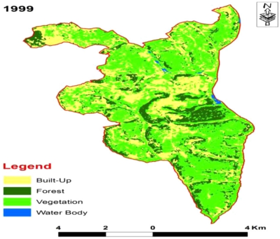
Fig. 6.
Land use/land cover pattern and the extent in Rusizi urban area by 1999. 
Fig. 7.
Land use/land cover pattern and the extent in Musanze urban area by 1999. 
Fig. 8.
Land use/land cover pattern and the extent in Kigali City by 2019. 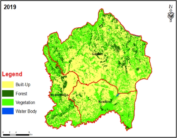
References
1. L. Mojica, J. M. hennebeg, Railways and populaion distribution: France, Spain, and Portugal, 1870-2000, J. Interdiscip. Hist., 42(1), 15-28(2011).
2. Department of Economic and Social Affairs, World Urbanization Prospects: the 2018 revision, in Proceedings of the United Nations., UN, New York:(2019).  3. Department of Economic and Social Affairs, World Urbanization Prospects: the 2014 revision, in Proceedings of the United Nations UN, New York(2015).
4. J. WU, J. Huang, X. Han, Z. Xie, X. Gao, Ecology. Threegorges dam--experiment in habitat fragmentation?, Science., 300(5623), 1239-1240(2003). 5. A. Sancini, F. Tomei, G. Tomei, T. Caciari, V. D. Giorgio, J. C. Andrea, P. Palermo, G. Andreozzi, N. Nardone, M. P. Schifano, M. Fiaschetti, C. Cetica, M. Ciarrocca, Urban pollution, G Ital Med Lav Engon., 34(2), 187-196(2012).
6. State of the world's cities 2012/2013, in Proceedings of UN Habitat, United Nations Human Settlements ProgrammeNairobi(2013).
7. G. Nishimwe, D. M. Rugema, C. Uwera, C. Graveland, J. Stage, S. Munyawera, G. Ngabirame, Natural captial accounting for land in Rwanda, Sustainability., 12(12), 5070(2020). 9. G. Chen, G. J. Hay, L. M. T. Carvalho, Object-based change detection., 33(14), 4434-4457(2012).
10. A. S. Minale, Population and enviroment interaction: the case of gilgel abbay catchment, E3 Journal of Enviromental Research and Management., 4(1), 153-162(2013).
11. N. L. Nemerow, F. J. Agardy, P. J. Sullivan, J. A. Salvato, Enviromental enginnering: Enviromental health and safety for municipal infrastructure, land use and planning, and industry, 6th ed., USA(2009).
12. S. Nii, S. N. A. C, Integrating remote Sensing, GIS, census, and socioeconomic data in studying the population-land use/ cover nexus in Ghana: a literature update, Africa development., 32(2), 197-212(2007).
13. C. Xiong, V. Bechkmann, T. Rong, Effects of infrastructure on land use and land cover change(LUCC): the case of Hangzhou International airport, China, Sustainability., 10(6), (2013). 14. Africa: Atlas of our changing environment, in Proceedings of United Nations Environment Programme, (2008).
15. National roadmap for green secondary city development, in Proceedings of the Global Green Growth Institute, Republic of Rwanda(2015).
16. R. J. Chiwa, Effects of land use and land cover changes on the hydrology of Weruweru-kiladeda sub-catchment in Pangani river basin, Tanzania, Kenyatta University Institutional Repository pp. 156/10442(2008).
17. S. M. Bassem, Water pollution and aquatic biodiversity, Biodiversity International Journal., 4(1), 10-16(2020).
19. The national risk atlas of Rwanda, in Proceedings of ACP-EU Natural Disaster Risk Reduction Program, MIDIMAR, Rwanda(2015).
|
|